The New Zealand Land Cover Explorer is a sister tool to the main Our Environment Mapping Tool. This guide will introduce you to the basics of using this free service.
This tool allows you to view changes and issues relating to New Zealand's land cover, by exploring different versions and 'views' of the Land Cover Database NZ.
To access it, select the Maps & Tools > Explore NZ Land Cover Change option from the menu at the top of the page (or click here). On first load of the tool, it is recommended to click the ![]() button, as this will give you a quick overview of how the tool works. In addition, you can use the "Examples" dropdown to see various examples of particularly interesting changes in land cover that has occurred.
button, as this will give you a quick overview of how the tool works. In addition, you can use the "Examples" dropdown to see various examples of particularly interesting changes in land cover that has occurred.
N.B.
- Land cover maps don't appear until you zoom in to the map to around 1:550k.
- The direction of change buttons:

 allow you to switch the map between looking at where land cover has become a particular type and where land cover is no longer a particular type.
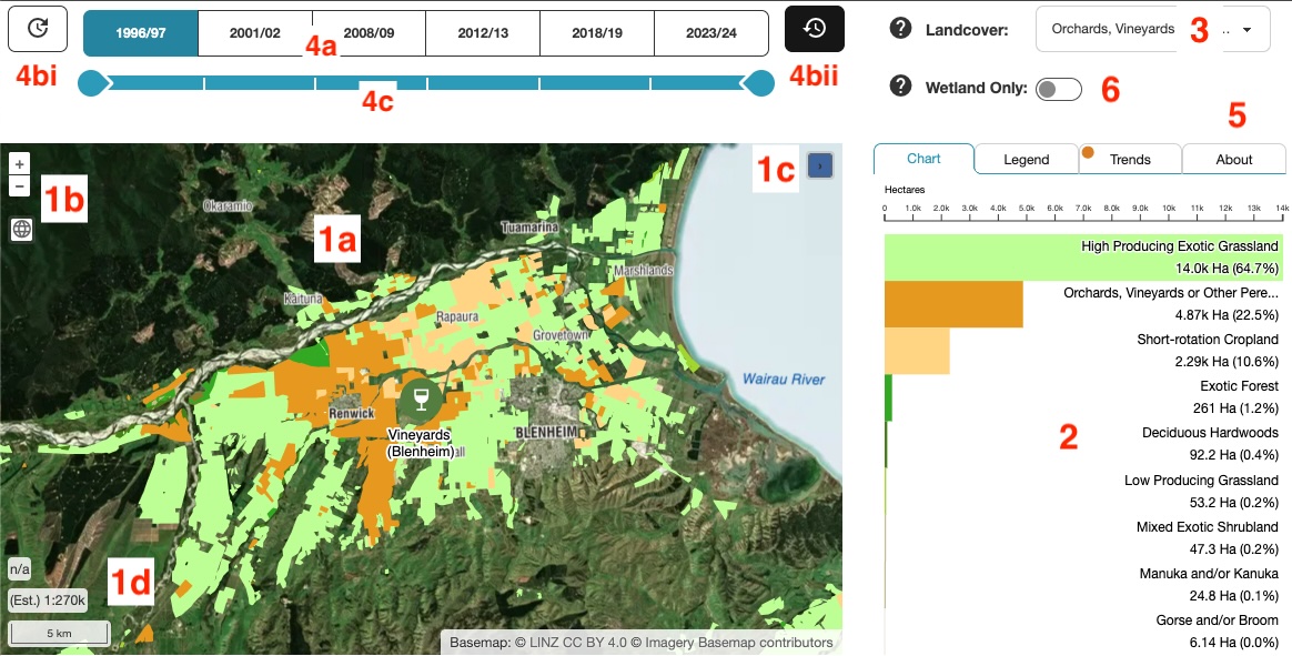
Fig. 1. Land Cover Explorer tool.
1a. Main map window - Interact with and view landcover change map.
1b. Zoom controls - Zoom in and out of the map & reset map to full extent.
1c. Overview map - Shows the larger geographic context of your current map.
1d. Scale / cursor position information.
2. Chart panel - Shows a bar chart (or sankey diagram if the "Trends" tab is active) of the landcover visible in the current map extent.
3. Land cover type dropdown - Change the land cover type displayed on the map.
4a. Year / LCDB version buttons - Change the year being displayed on the map.
4b. Direction of change buttons.
4bi. See what land is no longer a particular land cover type.
4bii. See what land has become a particular land cover type.
4c. Slider to set comparison year & animation limit.
5. Side panel tabs - Access bar chart, legend, trends or the about section.
6. Wetland only switch - When this is active, only landcover that is defined as wetland is shown on the map.
Additional controls

Fig. 2. Land cover Explorer additional controls.
1. Introductory tour - takes you on a quick tour of the tool, showing the major features.
2. Examples dropdown - choose to fly to some particularly interesting examples of land cover change over time.
3. Play / pause animation - loops over the time periods, allowing a simple animation of land cover change to play through.
Last updated: 1 November 2025
The New Zealand Land Cover Explorer is a sister tool to the main Our Environment Mapping Tool. This guide will introduce you to the basics of using this free service.
This tool allows you to view changes and issues relating to New Zealand's land cover, by exploring different versions and 'views' of the Land Cover Database NZ.
To access it, select the Maps & Tools > Explore NZ Land Cover Change option from the menu at the top of the page (or click here). On first load of the tool, it is recommended to click the ![]() button, as this will give you a quick overview of how the tool works. In addition, you can use the "Examples" dropdown to see various examples of particularly interesting changes in landcover that has occurred.
button, as this will give you a quick overview of how the tool works. In addition, you can use the "Examples" dropdown to see various examples of particularly interesting changes in landcover that has occurred.
N.B.
- Land cover maps don't appear until you zoom in to the map to around 1:550k.
- The direction of change buttons: allow you to switch the map between looking at where land cover has become a particular type and where land cover is no longer a particular type.

Fig. 1. Land Cover Explorer tool.
1a. Main map window - Interact with and view land cover change map.
1b. Zoom controls - Zoom in and out of the map & reset map to full extent.
1c. Overview map - Shows the larger geographic context of your current map.
1d. Scale / cursor position information.
2. Chart panel - Shows a bar chart (or sankey diagram if "Trends" tab is active) of the land cover visible in the current map extent.
3. Land cover type dropdown - Change the land cover type displayed on the map.
4a. Year / LCDB version buttons - Change the year being displayed on the map.
4b. Direction of change buttons.
4bi. See what land is no longer a particular land cover type.
4bii. See what land has become a particular landcover type.
4c. Slider to set comparison year & animation limit.
5. Side panel tabs - Access bar chart, legend, trends or the about section.
6. Wetland only switch - When this is active, only land cover that is defined as wetland is shown on the map.
Additional controls

Fig. 2. Land Cover Explorer additional controls.
1. Introductory tour - takes you on a quick tour of the tool, showing the major features.
2. Examples dropdown - choose to fly to some particularly interesting examples of land cover change over time.
3. Play / pause animation - loops over the time periods, allowing a simple animation of land cover change to play through.
Last updated: 1 November 2025
The New Zealand Land Cover Explorer is a sister tool to the main Our Environment Mapping Tool. This guide will introduce you to the basics of using this free service.
This tool allows you to view changes and issues relating to New Zealand's land cover, by exploring different versions and 'views' of the Land Cover Database NZ.
To access it, select the Maps & Tools > Explore NZ Land Cover Change option from the menu at the top of the page (or click here). On first load of the tool, it is recommended to take the tour via the ![]() button, which is accessed via the dropdown panel expanded via
button, which is accessed via the dropdown panel expanded via ![]() button) as this will give you a quick overview of how the tool works. In addition, you can use the "Examples" dropdown to see various examples of particularly interesting changes in land cover that has occurred.
button) as this will give you a quick overview of how the tool works. In addition, you can use the "Examples" dropdown to see various examples of particularly interesting changes in land cover that has occurred.
N.B.
- Land cover maps don't appear until you zoom in to the map to around 1:270k.
- The direction of change buttons: allow you to switch the map between looking at where land cover has become a particular type and where land cover is no longer a particular type.

Fig. 1. Land Cover Explorer tool.
1a. Main map window - Interact with and view land cover change map.
1b. Zoom controls - Zoom in and out of the map & reset map to full extent.
1c. Overview map - Shows the larger geographic context of your current map.
1d. Scale / cursor position information.
2. Chart panel - Shows a bar chart (or sankey diagram if "Trends" tab is active) of the land cover visible in the current map extent.
3. Year / LCDB version buttons - Change the year being displayed on the map.
4. Info panel tabs - Access bar chart, legend, trends or the about section.
5. Show additional controls - This expands a panel which contains various controls. Details below.
Additional controls

Fig. 2. Additional controls.
5a. Introductory tour - takes you on a quick tour of the tool, showing the major features.
5b. Play / pause animation - loops over the time periods, allowing a simple animation of land cover change to play through.
5c. Examples dropdown - choose to fly to some particularly interesting examples of land cover change over time.
5d. Land cover type dropdown - Change the land cover type displayed on the map.
5e. Wetland only switch - When this is active, only land cover that is defined as wetland is shown on the map.
5f. Collapse this control panel.
Last updated: 1 November 2025